Project: InaSAFE
Version: 3.2.0
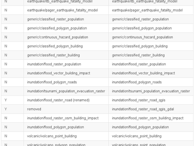
In InaSAFE 3.2 we have not added any new Impact Functions but we have made many refinements and improvements to the existing ones. We have also removed one Impact Function (inundation/flood_raster_road_qgis_gdal) to remove duplication and renamed one (inundation/flood_raster_road renamed to inundation/flood_raster_road_qgis) to make the nomenclature more consistent. As of version 3.2 we have 19 impact functions covering generic, inundation (flood and tsunami), earthquake and volcano hazards (see image for a complete list or this gist for the text version).
We have put a lot of work into improving the underlying architecture of Impact Functions so that code reuse is maximised and that they are described with rich, expressive metadata.