

Updating layer attributes
“A good content management system needs to ensure that the latest data is always available”
In order for an SDI to stay relevant it needs the spatial data to be updated as new versions become available. Spatial data represents real-world features. The world is constantly changing and this should also be reflected by the data. GeoNode provides a number of methods to ensure that the latest data can be made available, including:
- Editing layer data - this includes the modification and digitising of existing features within spatial layers, as well as the editing and update of attribute data from within the GeoNode interface.
- Layer replacement - an existing layer that has been defined can have the source data uploaded and overwritten with a new dataset, leaving the defined metadata, symbology and permissions already defined within GeoNode intact.
These mechanisms ensure that the data on the GeoNode platform can remain accurate and up to date, so that users can make informed decisions with the data.
You try:
Goal: To explore editing capabilities of GeoNode
Exercise 01 - Upload and edit attribute data
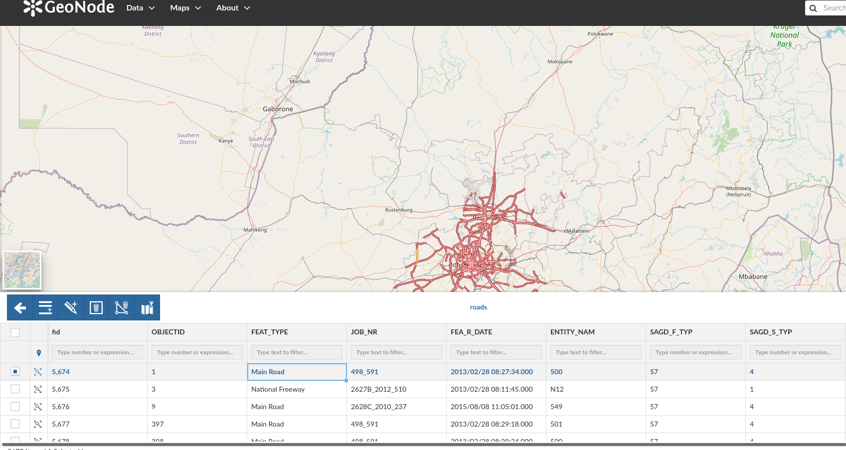
- Load the roads layer supplied with the exercise materials into GeoNode
- Make sure that the appropriate metadata is captured correctly and that the layer has a relevant title, such as OSM Roads
- From the Edit Data interface, filter the table using the values specified in the table below. How many rows are visible?
- Select a single row and enter edit mode
- Change the casing of the attribute value from the column FEAT_TYPE to uppercase eg slow >> SLOW.
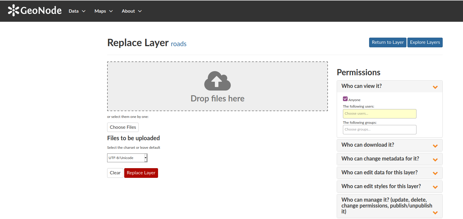
Exercise 02 - Perform an update using the layer data replacement feature
- Select the road layer uploaded in the previous exercise
- Choose Editing Tools and then select the Replace option
- Select the osm_railways layer from the exercise materials and replace the roads layer with the osm_railways layer.
For layers to be replaced on GeoNode the files must be named the same. Be sure to rename the osm_railways layer to "roads" before replacing it. Move the layer and auxiliary files to a separate folder as to not confuse them with the actual roads layer before renaming the files. - Update the metadata to suit the osm_railways layer
Check your results
Were you able to update the attributes of existing features?
Did you manage to update multiple features simultaneously?
Did you manage to replace the roads layer with osm_railways layer? Did you try to change the default style to be more appropriate?
Did you manage to update the metadata? Will other users be able to identify the change?
| Name | Expectation |
|---|---|
Feat Type ❗ |
Main Road |
Entity_Nam ❗ |
501 |
SAGD_S_TYP ❗ |
4 |
JOB_NR ❗ |
498_591 |
More about updating layers
There are some additional considerations when utilising the layer update functionality.
Layer data replacements
Replacing of complete layers should use the geometry type of existing layers. For example, in the exercise above, the roads layer can be replaced with the contents of the railway data as both feature sets are of the line geometry type. If, for example, the intention was to update the data with a street sign point dataset, this would not be feasible and a new layer would need to be created instead.
Layer data editing
When in edit mode, the following interface features can be leverage to enhance the editing capabilities for attribute data
- Bulk editing of attributes
- Zoom to the features for a selected row
- Advanced search for a feature in the attribute table
- Column level filter using expressions or numbers
- Hiding columns to only show important columns
- Ability to sync selected row with map, limiting the records in the attribute table to those that match features present in the map frame
- Ability to add a new feature by adding a shape corresponding to the layer geometry type
About refreshing attributes and statistics
GeoNode provides a layer function for attribute and statistic refreshing. This function ensures that the GeoNode system has the most up to date information, including when the latest edits were made or what attribute values are available, and is useful in many contexts, including:
- Where the data is edited from a remote datasource such as a database
- Other users have made changes whilst the layer is being reviewed
This process is distinct from layer updates as it does not make changes to the underlying data itself, but rather updates the available metadata for a layer within the GeoNode platform.

Check your knowledge:
-
Is it possible to edit the attributes of raster data:❗
- Yes
- Raster data does not have attributes
- No, GeoNode does not expose the attributes of raster layers
-
Is it possible to replace a vector layer with a raster layer:❗
- No, their data models are completely different
- Yes, they are all stored in the same GeoNode instance
- Yes, as long as they have matching geometry types
-
Is it possible to also edit the geometry of an existing feature whilst in edit mode for attributes:❗
- No, edit mode is restricted to attributes only
- You are only allowed to create new shapes
- You can edit an existing geometry to some extent

Further reading:
Download the sample data for the lesson.